David Mearns - Search Director, The Finding Sydney Foundation
Wreck of HSK Kormoran Discovered
The wreckage of the German Raider HSK Kormoran was found by the search team on board the SV Geosounder at 17:30 (AWT) on March 12th, 2008 in the approximate position 26° 05' 49.4" S 111° 04' 27.5" E. With Kormoran’s sinking position established, and the identity of its wreckage confirmed on the basis of high quality sonar imagery, the search for HMAS Sydney (II) has been localised to a most probable area and this search is currently ongoing.
Kormoran’s wreckage consists mainly of several pieces of hull amidst a large and dense field of debris, which is indicative of a ship that has suffered a catastrophic explosion. Following the initial discovery of the wreckage field using the 6 kilometre swathe of the SM30 sonar, a series of higher resolution sonar images were made that revealed additional information to confirm the identity of the wreck and its condition, as summarised below:
-
The wreckage of Kormoran was first found on Line #09 in the northeast quadrant of the designated 1,768 nm² search box. Line #09 was the fourth search trackline to be run and the SM30 sonar had been deployed for approximately 64 hours in the search box (excluding the time for turns) when the wreckage was first discovered. The depth of the site is approximately 2,560 metres.
-
The wreckage fits perfectly with what we know and expected to see for Kormoran from testimony of the German survivors. The vessel suffered a catastrophic explosion after its cache of some 320 mines stored in the after cargo holds 4, 5 and 6 detonated. This section of the vessel’s hull has been obliterated.
-
There are 4 large pieces of hull structure remaining. The two largest pieces are located hundreds of metres outside the main debris field and approximately 1,200 metres from each other on a line running roughly north-south. The distant locations of these pieces indicate that they sank after the explosion and/or took different glide planes in their descent to the seabed.
-
In addition to matching the known breadth of Kormoran, which was significantly greater than Sydney’s breadth, the piece was revealed to have a raised forecastle deck like Kormoran. The forward part of the bridge superstructure was intact at roughly the correct distance from the stem. Lastly, the sonar imagery indicates an opening in the deck in approximately the correct position for the forward cargo hold.
-
The other large pieces of hull were not able to be identified. However, based on their dimensions and position relative to the blast, it is possible that these pieces are the stern/poop deck and at least part of the engine room/hull structure aft of the main bridge superstructure.
Scene of Engagement between Kormoran & Sydney Found
On line #09, less than 4 nautical miles south of the Kormoran wreckage position a separate and distinct debris field was found at 19:16 (AWT) on March 12th, 2008. This debris was found to be widely scattered over a distance covering 1,700 metres and lying at a depth of 2,740 metres. However, it was not associated with any major shipwreck targets and was very sparse compared with the dense debris field found at the centre of Kormoran’s wreck location.
As Kormoran left the battle intact and was known to have drifted north with the prevailing current and winds after losing engine power, it is logical to conclude that this debris could not have come from Kormoran. However, the location of this wreckage in relation to the known movements of Kormoran in the final stages of the battle and her estimated leeway drift before sinking, does indicate that it marks the actual scene of action between Kormoran and Sydney.
This debris, therefore, must have come from Sydney as we know she had been gravely damaged by a torpedo hit and was being heavily shelled by Kormoran and in such a situation would have been losing pieces of structure and other parts of the ship overboard as was vividly described by the German eyewitnesses. Finally, the approximate NNE – SSW trend of this debris trail fits with the course of Sydney as she altered course south to avoid Kormoran’s fire.
Revised Planned Search Area for Sydney
Confirmation of Kormoran’s sinking position, as well as the location of the action between Kormoran and Sydney, has allowed me to refine the most probable sinking position of Sydney and outline a new search area for her wreck. This search for Sydney is currently ongoing.
Compared with the extremely large search area for Kormoran the initial search area for Sydney is relatively small and covers several hundred square nautical miles. Key to this initial search area are certain assumptions made about how far Sydney could have travelled away from the scene of action given the grave damage she had suffered – now proven by the extent and size of her wreckage found at the scene of action – and how long she could have remained afloat in such extreme condition.
Based upon the location of Kormoran, and the high quality sonar imagery that is being collected by the Williamson and Associates sonar team, I am confident that if the wreck of Sydney lies within our search area we will find her. Should this initial search area prove unsuccessful, the search area will be enlarged until the wreck of Sydney is found.
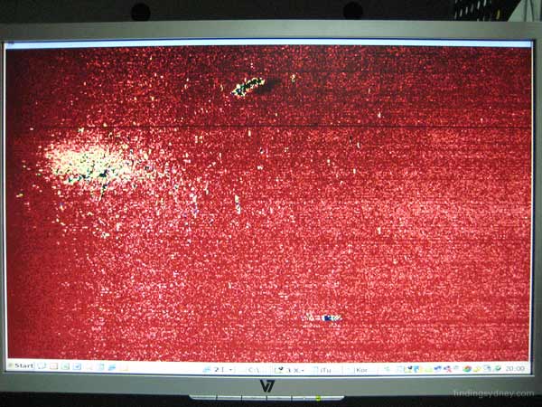
Above Photograph - Kormoran Wreckage 1: Sonar image showing the entire wreckage field of Kormoran when first located on 12th March. The object at the top of the screen with the dark acoustic shadow to its immediate right is Kormoran’s bow broken just aft of the bridge superstructure. The bright mass to the left and below the bow is the main debris field created as a result of the catastrophic explosion suffered by Kormoran when her cache of mines detonated. The object at the bottom of the screen is a large piece of unidentified hull structure measuring 31m x 25m x 12.7m high which gives a good idea of the scale of the wreckage.
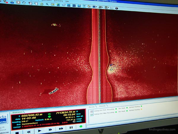
Above Photograph - Kormoran Wreckage 2: This is the second sonar image of Kormoran’s entire debris field taken at higher resolution. In this image the bow and its associated acoustic shadow are now at the bottom of the screen and individual pieces of wreckage in the debris field can now be resolved. This entire image covers an area 3,000 metres wide.
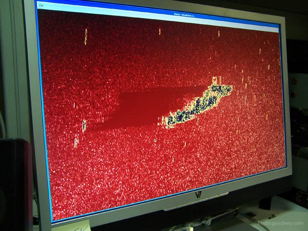
Above Photograph - Kormoran Bow 1: This image of Kormoran’s bow is a magnification of the previous image. This section of Kormoran’s hull measures 106 metres long by at least 20 metres wide, and extends from the tip of the bow to just aft of the bridge superstructure. Importantly, the beam of Kormoran’s hull (20.2 metres) is nearly 3 metres wider than Sydney’s hull (17.3 metres), which is a key measurement that allowed us to confirm the wreckage as Kormoran’s and not Sydney’s.
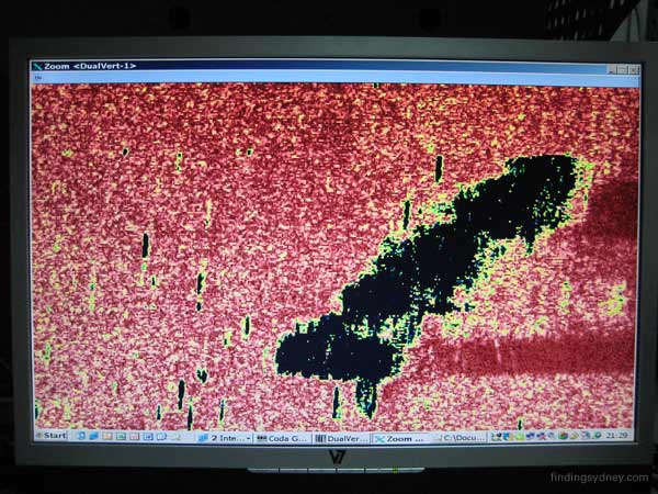
Above Photograph - Kormoran Bow 2: This final image of Kormoran’s bow (with the stem at the top of the image), collected using the highest resolution of the SM30 sonar (800 metre swathe), shows the crucial detail in the acoustic shadows trailing off to the right that confirmed the wreck as Kormoran’s. Kormoran has a flared bow with a raised foc’sle deck above the main deck. This structural detail, particular to Kormoran and not to Sydney, is evident by way of the acoustic shadow at the top of the image. This long shadow could only be caused by the wreck having the type of flared bow and raised foc’sle deck that Kormoran had. Fortunately, this section of hull is sitting upright on the seabed which allowed such analysis of the acoustic shadowing. The separate acoustic shadow at the bottom of the image is caused by the bridge superstructure of Kormoran, which has been measured to be in the correct position relative to the stem.
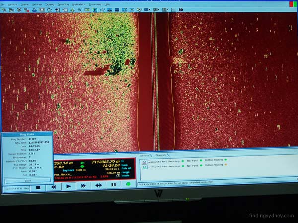
Above Photograph - Kormoran Debris 1: This sonar image shows the highly concentrated debris field left in the wake of the catastrophic explosion suffered by Kormoran. This explosion occurred when Kormoran’s cache of 320 mines detonated after the scuttling charges were set. The mines were stored in holds 4. 5 and 6 on the ship and this section of the hull has been obliterated by the enormous blast. Each yellow and dark blue sonar contact set against the red background of the seabed represents a single piece of the hundreds of individual pieces of wreckage debris scattered throughout the debris field.
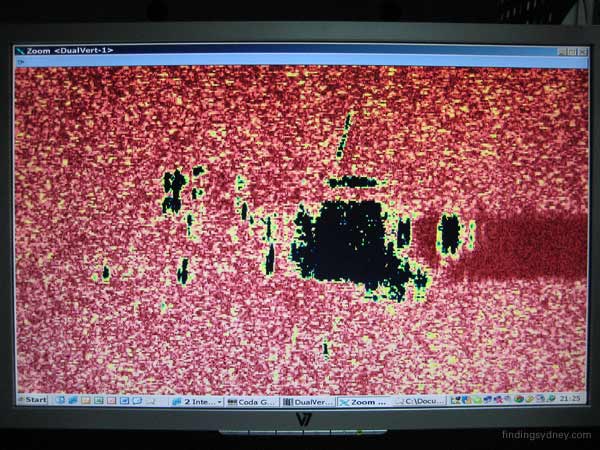
Above Photograph - Kormoran Hull Piece 1: This is an unidentified piece of Kormoran’s wreckage that is surely a major structural section of the hull given its size of 31 metres by 25 metres by 12.7 metres high. Remarkably, the large piece of Komoran’s hull was found 1,200 metres away from the bow.

Above Photograph - Battle Debris 1: This sonar image, covering a 750 metre expanse of the seabed, shows the wreckage found in the location four nautical miles south of Kormoran’s wreck site. The wreckage is widely scattered over a distance covering 1,700 metres and fits with the scenario of Sydney being torpedoed and heavily shelled by Kormoran resulting in the loss of pieces of structure and other and parts of the ship. The approximate NNW – SSW trend of this debris trail fits with the course of Sydney as she altered course south to avoid Kormoran’s fire.
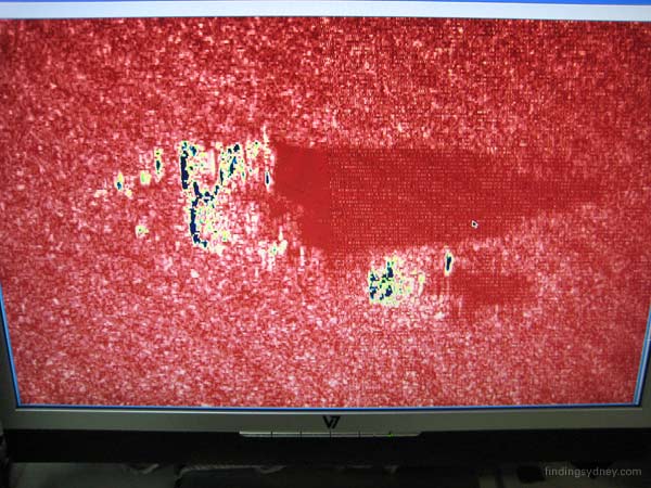
Above Photograph - Battle Debris 2: While most of the wreckage found at the battle site is smaller, this piece is very large and indicates the severe damage suffered by Sydney. The larger piece in this high-resolution sonar image measures 33 metres by 19 metres with a height of 13.3 metres off the seabed as evidenced by its very long acoustic shadow. The smaller wreckage at the bottom of the screen with its own acoustic shadow measures 11 metres by 11 metres and 5 metres high by comparison.
Lieutenant John Perryman, RANR – Senior Naval Historian & Official Observer
Discovery of the wreck of HSK Kormoran – Wednesday 12 March 2008
During the forenoon of Wednesday 12 March 2008, the HMAS Sydney (II) search team commenced a survey run down line number nine through the designated search box. Geographically this line ran from north to south along 111° 04’ 38”E of longitude and was 52 nautical miles in length.
At 17:30 a small dark contact appeared at the top of the SM30 side scan sonar display which we were monitoring in our survey room. David Mearns immediately classified the target as man made due to the characteristics it displayed such as hard straight edges, shadow and its horizontal orientation on an otherwise featureless seabed.
During the next hour the first evidence of a debris field began to appear and before long we were viewing a centralised concentration of debris indicative of a powerful and catastrophic explosion. This was consistent with the German account of the final destruction of the raider HSK Kormoran, scuttled by her crew following the engagement with HMAS Sydney (II). At the time of her scuttling she was carrying a full cargo of some 300 sea mines, each packed with high explosives.
Approximately 1200 metres to the south of the debris field a much larger target was detected, seemingly in tact, which was tentatively classified as being the forward section of the Kormoran. The position of the centre of the debris field which represents the site of the scuttling and resultant explosion is 26° 05’ 49.4” S 111° 04’ 27.5” E in a depth of 2560 metres of water.
As we continued to the south along our survey line, several further contacts were detected approximately four nautical miles from the first wreck field. Although these contacts displayed hard edges and man-made characteristics, the absence of a debris field led us to conclude that this could be wreckage which may have been blown from either vessel during the action. Sydney is reported to have received major hits from Kormoran early in the engagement which included losing the top of the housing of her ‘B’ gun turret. She also suffered a torpedo hit beneath her two forward turrets. It is likely that this wreckage could well have been shed from Sydney as a result of battle damage and lie in the vicinity of the initial engagement. There was, however, no evidence of a major shipwreck in the immediate vicinity of these contacts.
News of the potential discovery of Kormoran was reported through the Finding Sydney Foundation to appropriate Government authorities ashore while the Geosounder continued its run to the south. During the passage south, the data collected from the shipwreck field received further scrutiny from David Mearns and specialists from the Williamson team who concluded that the wreck displayed characteristics conforming closely to that of the Kormoran. Notwithstanding this positive affirmation it was decided that at the end of the next south-north run we would re-visit the first wreck field and make a high resolution pass of it with the SM30 to gain absolute proof that our belief that this was Kormoran was correct.
On Friday 14 March 2008 we were again in the northern end of our search box where we began the first of two high resolution passes. The first pass began at 14:30 and provided some useful additional data. The second pass commenced at 19:32 and soon revealed evidence of shadow on the large hard contact which we had tentatively classified as the forecastle section of Kormoran. This shadow provided further clues concerning the size of this contact which is estimated to be approximately 106 metres long. Two large pieces of wreckage were also detected in the centre of the debris field along with many other hard contacts.
The dimensions of the largest piece of Kormoran’s wreck along with other distinguishing features such as her rising flared bow section were compared to the characteristics of Sydney. From the dimensional information before us when compared to Kormoran’s drawings, it was concluded that the size of the wreckage was not commensurate with that of a modified Leander class cruiser but was consistent with the ship data held for HSK Kormoran. Of significance was the beam measurement of the contact which very closely matched the 20.2 metre beam of Kormoran but not the 17.3 metre beam of Sydney. It is therefore our considered opinion that this was indeed the wreck of Kormoran lying in close proximity to clear evidence of a catastrophic explosion.
We then continued our late night survey to the area where we had previously detected additional wreckage, and tentatively classified as the site of the battle between Sydney and Kormoran. We commenced the start of our high resolution run down the line at 23:13 and in the early hours of Friday morning we relocated the several hard pieces of wreckage in position 26° 09’ 45.9” S 111° 04’ 07.2 E. Some of these pieces were measured and found to be surprisingly large with one piece measuring 33 metres x 19 metres and standing 13.3 metres high off the seabed casting a distinctive acoustic shadow. At this stage we can only speculate on what this large piece of debris might be. This leads us to believe this could be wreckage blown from Sydney during her engagement with Kormoran.
While these discoveries took place several days ago it was considered important that they be thoroughly analysed before any official statement was released. Out intent now is to continue the search in a box which has been further refined by David Mearns to fulfil our ultimate goal and locate the wreck of HMAS Sydney (II).
Glenys McDonald - Director, The Finding Sydney Foundation (Observer)
After a week at sea and dogged by bad luck, by Wednesday 12 March we were finally in survey mode. Late in the afternoon John, David and I were sitting in our work space discussing the day and at the same time keeping an eye on our sonar screen. It was exactly 17: 30 and John was the first to comment on the target beginning to emerge. Before our eyes a spectacular vision of a huge explosive pattern appeared, together with two substantial pieces of debris. “That’s it” said David, and the excitement was palpable. I ran to call the Electric Pictures team so the screen could be filmed as it happened.
The largest piece of debris certainly fitted the shape of a large section of Kormoran’s bow. The scenario unfolding on the sea bed fitted the description of the last moments of HSK Kormoran. It was quite sobering to comprehend that here, just five nautical miles south east of the 26S 111E marker, lay HSK Kormoran, and I took pause to remember that eighty German sailors did not survive this sinking.
After returning from dinner to more screen watching as we headed south on our track line, it was obvious that at 19:30 we were entering the debris field of the battle site, some four nautical miles south of the Kormoran. Interrogations of the Germans had indicated that Sydney lost her B turret housing which was blown overboard during the battle, and here on the seabed was a large item. How quickly our fortunes have changed in just one day.
We continued on in our search from HMAS Sydney, but on Friday our track line took us near the Kormoran position and we took the opportunity to do some high resolution work. We did two passes of the Kormoran position on Friday, the second at a 800m swathe and with the fish at altitude 40 meters. Finally we had absolute certainty that we were looking at Kormoran at 26 05 49S 111 04 27E in 2560 meters of water.
It was 23:00, but the work continued as the Geosounder proceeded to the battle area with the same swathe and depth coverage. It was sobering to realise that we were passing through the actual battle site. More debris appeared, but we waited with baited breath for the large piece of debris we had tracked before. There was an audible gasp as it appeared on the screen because it was so large and cast such a shadow. It certainly looked like a very large piece of Sydney was blown overboard during the battle. By 0100 hrs on Saturday I called it a night, satisfied that David Mearns and the Williamson crew had given the Finding Sydney Foundation the best sonar pictures available of both the Kormoran and the battle site. I wished my fellow Directors was here to share this with me. But our task is not yet complete, and we continue on track to locate HMAS Sydney.
IMPORTANT NOTICE: The Material (including photographs) available in the "Press Room" section of this Website may be used/reproduced unaltered by your organisation (unless stated otherwise within the content description) subject to the terms and conditions set out in the Legal Section AND any Material (including photographs) which you use/reproduce must credit the source as "The Finding Sydney Foundation" and, as an option, you may also link the source statement with the website address http://www.findingsydney.com/.